The study of hydrotoponymy shows a prevalent initial Old European layer in central and northern Germany, too, similar to the case in Iberia, France, Italy, and the British Isles.
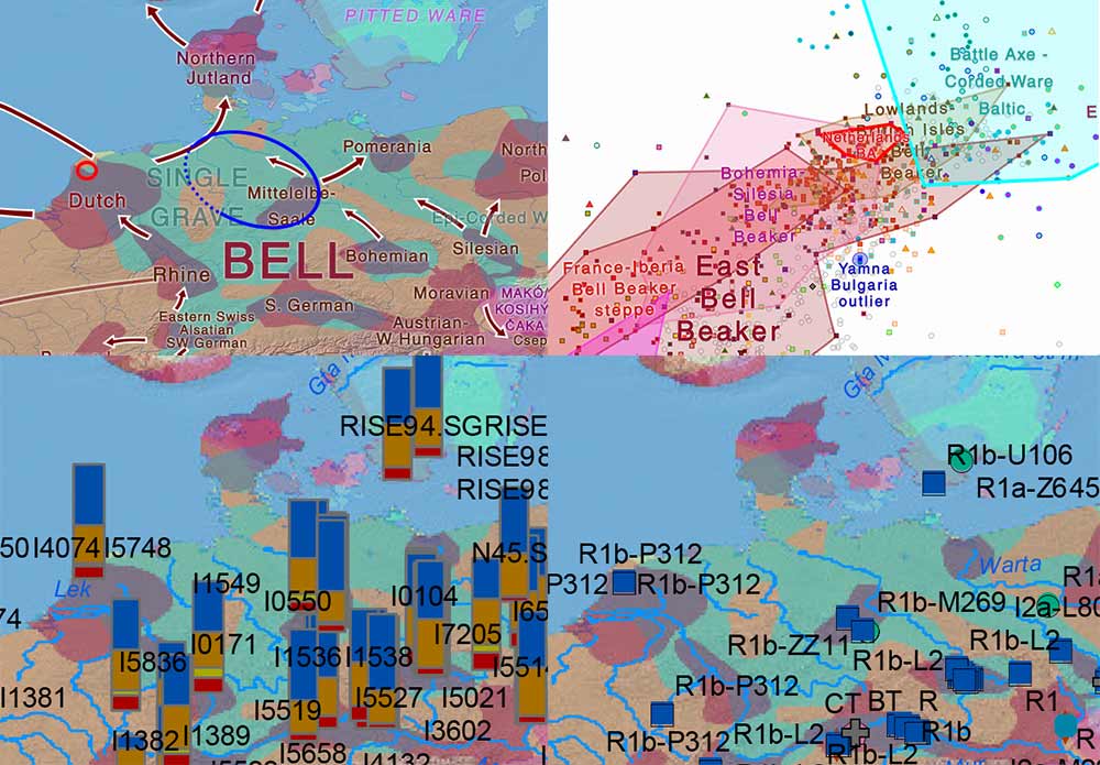
The recent paper on Late Proto-Indo-European migrations by Frederik Kortlandt relies precisely on this ancestral layer as described by Jürgen Udolph to support a Danubian expansion of North-West Indo-European with East Bell Beakers, identified as the Alteuropäische (Old European) layer that was succeeded by Germanic in the North European Plain.
The Proto-Germanic homeland
The following are excerpts are translated from the German original (emphasis mine) in Udolph’s Namenkundliche Studien zum Germanenproblem, de Gruyter (1994):
The following is a concise compilation of the investigation into nine points, which will be subsequently discussed: there are Brink (in the north brekk-), -by (on the Elbe), the name of the Elbe itself, germ, haugaz and blaiw, klint, malm / melm, the name of the Rhön, and the place name element -wedel.
I want to briefly summarize the results:
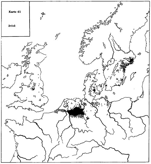
1. Brink has toponymically a clear focus in Germany between the Rhine and the Weser; in Schleswig-Holstein and Denmark it is almost completely missing, the Scandinavian place name documents show an accumulation in eastern Sweden. The English Brink names can not be associated with the Scandinavian ones. The “real” Scandinavian variant brekka, brekke, however, also appear on the Shetland and Orkney Islands and in central England.
2. The Central Elbian –by-place names have nothing to do with the Danish and Scandinavian -by-names.
3. The name of the Elbe has been carried from south to north and has become an appellative in Scandinavia. This clearly proves that a south-north migration has taken place.
4. The distribution of haugaz does not support a Nordic origin of the word. K. Bischoff in his thorough investigation never asked whether the reverse path from south to north would be possible. However, in comparison with the results of the study of other toponyms, this second option will be much more likely to be accepted. On the “problem of the gap” in the distribution (between Aller and northern Holstein) see page 910.
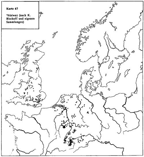
5. Completely missing is the assumption of Nordic origin in the case of hlaiwaz. A look at Map 67 shows this clearly.
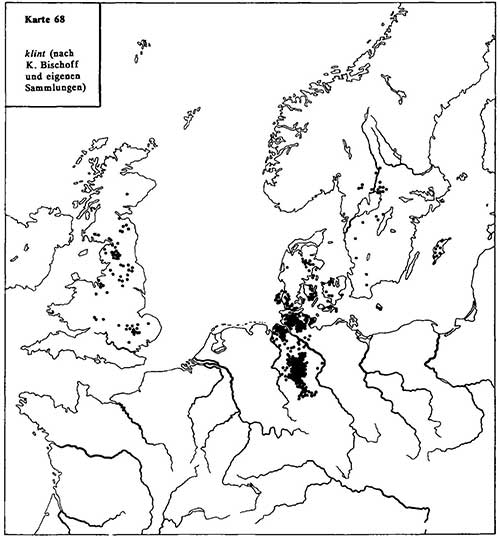
6. Even in the case of klint, Denmark and Scandinavia are only marginally involved in the distribution of names. This contradicts the thesis that the English Klint names are of Nordic origin. On the other hand, Map 68 (Klit- / Klett-) shows how Nordic place names can have an influence on the British Isles.
7. Even in the case of germ, melm (ablauting malm, mulm), everything speaks for a continental Germanic starting point: here are all ablaut stages in the appellative vocabulary and in the toponymy, which shows together with the name Melmer perhaps the most ancient -r-derivations, which are unknown to the Nordic area, while the Nordic names, in turn, have a distinct tendency to spread to eastern Sweden, towards the Baltic Sea.
8. The name of the Rhön can only be interpreted with the aid of the Nord Germanic apellative hraun “boulder field, stony ground, lava field”. This does not mean that Nord Germanic peoples have given this name, but that the Common or Proto-Germanic peoples knew the appelative still. The Rhön owes its name to this language stage.
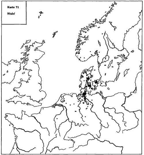
9. The spread of the fronds names in Germany, classified by E. Schröder as “North Germanic invasion”, can be explained differently: more important than the often younger names north of the Elbe in Schleswig-Holstein (type Wedelboek) are the place names near Braunschweig, Büren (Westphalia), and in the Netherlands, in which case a south-north spread is more convincing than the assumption of a Nordic expansion.
If you take the similar distribution maps 15 (wik), 31 (fenn), 36 (slk), 39 (büttel), 47 (live), 49 (quem), 50 (thing), 61 (brink) and 66 (haugaz) It can be seen from this (page 72, page 908) that there are parts of Germany which, to a lesser degree, are more heavily involved than others in Old Germanic place name formations: that applies to southern Thuringia, the Area between Werra and Fulda, the Magdeburger Börde and its western foothills to the Weser at the Porta Westfalica). On the other hand, the areas north of the Aller, Hanoverian Wendland and wide areas between the Lower Weser and the Lower Elbe (apart from the area around Osterholz-Scharmbeck as well as Kehdingen and Hadeln) are little and hardly affected.
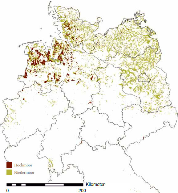
There is no question that the reasons for the different dispersion can not lie in the name itself, but have other causes. H. Kuhn has considered the natural conditions of the landscape with the fronds. Comparing the place name expansion outlined here with a bog map of Lower Saxony, as found in numerous publications (Map 73, page 910), solves the problems: even today’s bog distribution of Lower Saxony, diminished through cultivation and drainage (albeit still considerable), reflects the fact that the early colonization and naming of northern Germany has been shaped and, to a certain extent, controlled by settler-friendly and not-settler-friendly conditions.
On the location of the Germanic Urheimat
According to the space briefly outlined by the present study, the Old Germanic settlement area in toponymic terms is roughly to be located between the Erzgebirge, Thüringerwald, Elbe, Aller and an open border in Westphalia, for the following reasons:
- High proportion of old European names. This is a basic requirement, which of course is also fulfilled by other areas, but not by Schleswig-Holstein, Denmark and Scandinavia. (…)
- Of particular importance was the discussion about relations with the north (the generally accepted ancient Germanic settlement area, section L, p. 830-917). I believe that the detailed study of the geographical names no longer allows one to assume a Scandinavian homeland of Germanic tribes. Too many arguments speak against it. It is much more likely to start with a northward migration (…).
Western border: Nordwestblock
Recently, W. Meid has once more dealt in detail with Kuhn’s thesis. After that, the most important criteria for the approach of this thesis are the following:
- -p- (and other shutter sounds) are partly not shifted in North German names;
- the existence of a -sí-suffix;
- -apa in river names;
- the suffix -andr-;
- certain words u. Name strains, e.g. Veneter, Belgian.
- Above-average relations of the northwestern block to Italic (Latin, Osco-Umbrian).
W. Meid agrees with Kuhn’s theses, but with limitations: “These evidences seem to indicate that the NW-space did not belong to the original settlement area of the Teutons, but that the Germanization of this area or larger parts of it did not take place until relatively late, namely – as Kuhn thinks – after the Germanic sound shift or during its last phase. According to Kuhn’s own words this “space… appears as a block that has long defied Germanization”.
Udolph continues explaining why most of these non-Germanic examples are “optic illusions”, since he can explain most of them as from Old European to Old Germanic stages, which is mostly in agreement with the known features of Old European hydrotoponymy. For example, -apa- and -andra-names as Old European; -p- as before the Germanic sound shift; -st- and -s-formations as Northern European; -ithi- also unrelated to a hypothetic “Venetic” substrate.
I think that the point to discuss should not be the similarity with Old European or the oldest reconstructible Proto-Germanic stage (i.e. the closest to North-West Indo-European), or the appearance of these traits also in neighbouring Germanic territory, but the proportion of “more archaic” features contrasting with the proper Germanic area, and thus differences in frequency with the Germanic core territories.
Just as Udolph can’t accept the non-Indo-European nature of most cases, one can’t simply accept his preference for a Pre-Proto-Germanic nature either, for the same reason one can’t accept the relationship of Western European “Pre-Celtic” hydrotoponymy with Celtic peoples because of some shared appellatives whose Celtic nature is not proven.
NOTE. If there is something missing from this huge book is certainly statistical analyses with GIS, which would make this case much easier to discuss in graphical and numerical terms. Let’s hope Udolph can update the data in the near future, because he is still (fortunately) active.
In any case, the Nordwestblock remains a likely Old European hydrotoponymic area partially shared by Germanic, which doesn’t lie at the core of the spread of Old European place names and has a potential non-Indo-European substrate shared with Northern European groups. Combined with comparative grammar and with results of population genomics supporting the spread of East Bell Beakers of Yamna descent from the Carpathian Basin, this essentially renders interpretations of Old European expansion from Northern Europe devoid of support in linguistics.
Palaeo-Germanic expansion
To the north, the settlement movement depends on the location and spread of settlement-deficient areas, such as the moors northeast of Wolfsburg, north of Gifhorn, south of Fallingbostel, etc. As soon as this belt has been breached, the place name frequency in the eastern Lüneburg Heath indicates where more favorable settlement conditions are to be found: the Altmark in Saxony-Anhalt, the Jeetzel lowlands and especially the Ilmenau area near Uelzen, Bevensen and Lüneburg (it is difficult not to recall the name Jastorf here).
If one combines these findings with the dispersion of ancient Germanic place names, one will find that above all the section of the river east from Hamburg to about Lauenburg was particularly favorable for crossing. The onomastic data speaks in favour of this aspect, e.g. the following names lying north and south of this area.
1. Delvenau = Elbe-Lübeck Canal.
2. Neetze north of Lüneburg (-d-/-t-change).
3. Wipperau north of Lüneburg (-p-/-b- change).
4. The dispersion of the -wik places (Bardowik), cf. Map 15, p. 106.
5. The dissemination of the -r formations (Map 24, p. 191).
6. The -ithi formations Geesthacht, Bleckede u.a. south of the Elbe, Eckede north of the stream (see Map 28, p.272).
7. Fenn south of the Elbe in the north of Lüneburg (Map 31, p.315).
8. The distribution of the Hor name (Harburg) and northeast of it in Holstein (Map 32, p.328).
9. Germ, sik- with clear clusters southeast. and northeastern. from Hamburg (Map 36, p. 409).
10. Also the -büttel names show a concentration east of Hamburg on the one hand and a second accumulation at the estuary of the Elbe (Brunsbüttel) (map 39, p.438).
11. Gorleben and other places in Hann. Wendland south of the river (Map 47, p.503).
12. Werber-names southeast from Hamburg and in eastern Holstein (Map 53, p.742).
13. The scattering of brink names (Map 61, p. 843).
The place name distributions also make it possible to track the settlement movement north of the Elbe. It has been repeatedly emphasized that Schleswig-Holstein has little share in old Germanic toponymy. One tries to explain this fact, which reaches into the realm of the Old European hydronyms, by saying that, according to archeology, “large parts of Schleswig-Holstein in the 5th to 7th centuries were sparsely populated”.
If one summarizes these synoptically (Map 74, p.914) and also takes into account the not-included -leben-names (Map 47, p.503), then it is quite clear that Denmark by no means shares these types of names. The most important points are, in my opinion:
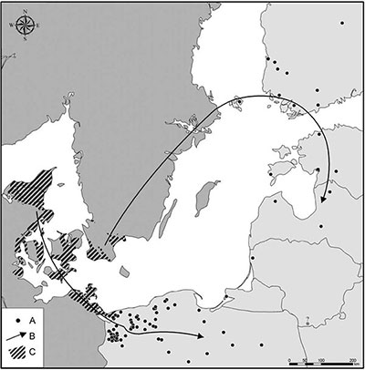
- North of today’s German-Danish border, the quantity of old place names drops rapidly and even tends towards zero. West Jutland in particular is rarely involved in the dispersion.
- Within Jutland there is a clear orientation to the east. The connection with southern Sweden is established via Funen and Zeeland.
- Disputed is in my opinion, whether the spread of toponymy followed a roughly direct line Fehmarn and Lolland/Falster. This is not to be excluded, but the maps of toponymy distribution do not give a clear indication in this direction.
The synoptic map makes it clear that both western Schleswig-Holstein and western Jutland are not to be regarded as Old Germanic settlement areas. Rather, East Jutland and the Danish islands were reached by Germanic tribes.
Absolute chronology and Balto-Finnic
It is imprecise to estimate the age of settlement movements from toponymic research. I do not want to be involved in speculation, but I think that Klingberg’s estimate could have some arguments in its favor. In the approximate dating, however, it is important to include a fact that has already been briefly mentioned above and should be treated here in more detail: the fact of Germanic-Finnic relations.
W.P. Schmid has emphatically pointed out the difficulty that arises when one considers the unfolding of Germanic too far from the Baltic Sea settlement areas. Among other things, it draws attention to the fact that a Germanic homeland that were postulated too far west could not explain how Germanic loanwords might appear in the Finnic names of Northern Russia. These will be mentioned with reference to M. Vasmer: Randale to Finn. ranta “beach”, Pel’doza and Nimpel’da to Finn. pelto, Justozero to Finn. juusto “cheese”, Tervozero to Finn. terva “tar” and Rovdina Gora to Finn. rauta “ore”.
I think it is possible that the clear spread of Old and North Germanic toponyms, as described in the synoptic map 74 (p. 914) and in the already mentioned -ing, -lösa, -by, -sta(d) and -säter-maps (19, 46, 63-65), can offer some help: quite early the Germanic tribes reached the Swedish east coast. It is also clear that there have previously been contacts with Slavic and Finno-Ugric tribes by sea. However, intensive German-Finnic relations can, in my opinion, have come about only through close contacts on the mainland.
Pre-Indo-European substrate
In my investigation, I have repeatedly come up with suggestions to explain a hard-to-interpret North Germanic name from a Pre-Germanic, possibly Non-Indo-European substrate. Most of these were views of H. Kuhn, which he also used to support his so-called “Nord-West block”.
On one point H. Kuhn may have been right with an assumption of a Pre-Germanic substrate that did not provide the basis for further development in Germanic terms: he very clearly argued that Scandinavia too was Pre-Germanic, even Pre-Indo-European A substrate that stands out above all because of the lack of Lautverschiebung : “In the Nordic countries, we have to reckon with non-Germanic, non-Indo-European prehistoric names scarcely less than in the other Germanic languages”. In light of the results of the present work that makes a relatively late Germanization of Scandinavia very likely, this sentence should not be set aside in the future, but carefully examined on the basis of the material.
Both data, the known long-lasting Palaeo-Germanic – Finno-Samic contacts, and the underresearched presence of non-Indo-European vocabulary in Scandinavia, are likely related to the presence of a West Uralic(-like) substrate in Scandinavia and most likely also in Northern Europe, based on the disputed non-Indo-European components shared through the North European Plain (see above), and on the scarce ancient Indo-European hydrotoponymy in central-east Europe to the north of the Carpathians.
Population genomics
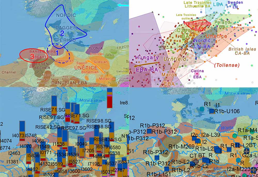
Although there is yet scarce genetic data from northern European territories, the haplogroup distribution among sampled peoples from the Germanic migration period and during the Viking expansion suggests a prevalence of R1b-U106 in the North European Plain (also found in Barbed Wire Beakers), and thus a later integration of typically Neolithic (I1) and CWC-related (R1a) subclades to the Germanic-speaking community during the expansion into Southern Scandinavia.
This is compatible with the described development of maritime elites by Bell Beakers, representing maritime mobility and trade, and an appealing ideology, similar to the prevalence of Athens over Sparta (Corded Ware in this analogy). It is also supported by the bottlenecks under R1b-U106 to the north of Schleswig-Holstein.
NOTE. Nevertheless, other R1b-L151 may have been part of the Germanic-speaking communities, especially during its earliest stage, and also R1b-U106 (and other R1b-L161) subclades may appear all the way from the Carpathians to Northern Europe, including the Eastern European Early Bronze Age.
Archaeology
This sudden population bust to the south and predominance of a Southern Scandinavian maritime society in the Nordic circle seems to be also supported by inferences from archaeological data, too. For example, from the recent Human impact and population dynamics in the Neolithic and Bronze Age: Multi-proxy evidence from north-western Central Europe, by Feeser et al. The Holocene (2019):
The second boom between c. 3000 and 2900 cal. BC relates to increases in the palynological proxy and the binned all site SCDPD curve. From an archaeological point of view, this time reflects the transition from the Funnelbeaker to the Single Grave Culture. The emergence of this new cultural phenomenon is often regarded to have been associated with a shift in subsistence practices, that is, a shift from sedentary agricultural to mobile pastoral subsistence (Hinz, 2015; Hübner, 2005; Iversen, 2013; Sangmeister, 1972).
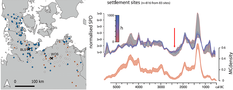
(…) there is palynological evidence for increased importance of cereal cultivation during the Young Neolithic in comparison to the Early Neolithic (Feeser et al., 2012). This, however, does not rule out an increased importance of pastoralism, as grazing on grasslands and extensive cereal cultivation are difficult to distinguish and to disentangle in the palynological record. Generally however, human impact on the environment and population levels, respectively, did not reach Funnelbeaker times maxima values during this boom phase at the beginning of the Younger Neolithic. The similar short-term synchronous developments in both the pollen profiles during 2800–2300 cal. BC could point to large-scale, over-regional uniform development during the Younger Neolithic in our study area (cf. also Feeser et al., 2016).
Between c. 2400 and 2300 cal. BC, the palynological proxy and the binned all site SCDPD curve show a similar distinct decrease (Figure 6), and we define a second bust phase accordingly. The soil erosion record, however, indicates elevated values at around this time but declines, although not very well defined, to a minimum at around 2200 cal. BC. Due to the generally low number of colluvial deposits recorded for the Younger Neolithic, this is not regarded to contradict our interpretation, as low sample sizes generally minimize the chances of identifying a robust pattern. A strong increase in all the three proxies between 2200 and 2100 cal. BC defines our third boom phase.
Bronze Age evolution
Candidate homelands for the succeeding (Palaeo-Germanic) stages of the language are shifted also in archaeology to the south, due to the economic influence of demographically stronger Nordic Bronze Age cultural groups of northern Germany over Southern Scandinavia.
A good description of societal changes in the Palaeo-Germanic stages is offered by the recent paper Cultural change and population dynamics during the Bronze Age: Integrating archaeological and palaeoenvironmental evidence for Schleswig-Holstein, Northern Germany, by Kneisel et al. The Holocene (2019):
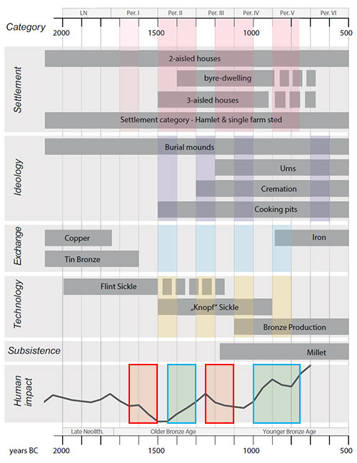
At each beginning of a boom phase and each end of a bust phase, changes in the material culture could be observed.
When the pressure on the landscape is at its lowest around 1500 BC and shortly before it rises again, the type of burial changes, hoards and bronzes increase, and monumental burial mounds are erected again. Vice versa, when the pressure on the landscape reaches its maximum value around 1250 BC, tools and hoard depositions decrease again and only the monumental burial and prestige goods are maintained. The ‘elite’ are continuing with their way of burial. The reduction in house surface area and the number of hoards takes place earlier, possibly because of material scarcity as could also be proven in Thy, northern Jutland (Bech and Rasmussen 2018).
Again, the human impact decreases, and at its lowest point at the beginning of Period IV ca. 1100 BC, the monumental burial custom and the addition of prestige goods also end. The number of hoards and graves begins to rise again, and cooking pits appear. Exchange networks shift with the beginning of Period V, while axes increase again together with a slight decrease in the human impact curve. The appearance of certain artefacts or burial rites at the beginning of such a period of upheaval seems to suggest the role of a trigger. With this analysis, we have defined several likely indicators for social change in the less distinct phases and societal change in the strongly pronounced phases around 1500 BC and 1100 BC and the most important triggers for the Schleswig-Holstein Bronze Age.

While population movements can’t be really understood without a proper genetic transect proving or disproving archaeological theories, it seems that the intermediate zone of the Nordic circle was subjected to at least two demographic busts and succeeding booms during the Middle and Late Bronze Age periods, which not only affected the hydrotoponymy of Schleswig-Holstein (see above), but probably served as dynamic changes in the linguistic evolution of Palaeo-Germanic-speaking communities up to the Common Germanic expansion.
Read more on the Northern Early Bronze Age province.
Related
- European hydrotoponymy (I): Old European substrate and its relative chronology
- European hydrotoponymy (II): Basques, Iberians, and Etruscans after Old Europeans
- Pre-Germanic and Pre-Balto-Finnic shared vocabulary from Pitted Ware seal hunters
- Kortlandt: West Indo-Europeans along the Danube, Germanic and Balto-Slavic share a Corded Ware substrate
- Pre-Germanic born out of a Proto-Finnic substrate in Scandinavia
- Bell Beaker/early Late Neolithic (NOT Corded Ware/Battle Axe) identified as forming the Pre-Germanic community in Scandinavia
- Reproductive success among ancient Icelanders stratified by ancestry
- Genomic analysis of Germanic tribes from Bavaria show North-Central European ancestry
- Germanic tribes during the Barbarian migrations show mainly R1b, also I lineages
- On Proto-Finnic language guesstimates, and its western homeland
- North-Eastern Europe in the Stone Age – bridging the gap between the East and the West
- Minimal Corded Ware culture impact in Scandinavia – Bell Beakers the unifying maritime elite
- On the origin and spread of haplogroup R1a-Z645 from eastern Europe